Difference between revisions of "1653: United States Map"
(→Table: Added details for some of the states.) |
(→Explanation) |
||
| Line 22: | Line 22: | ||
Other states that have not been moved a lot include California which has only been pushed down the length of the west border of the US (and thus rotated acordingly), so the top part still overlaps with the bottom part California, but also {{w|Arizona}} and {{w|New Mexico}}. {{w|Maine}} has only been rolled left (i.e. turned upside down) to just outside its normal position. {{w|Colorado}} has been moved up a state to where {{w|Wyoming}} usually is, and Wyoming has then just been shifted right. But both have been turned 90 degrees, whichever way would be impossible to say for these rectangular states. But the text, if you dare believe in that, seems to indicate they have been turned counter clockwise. {{w|Wisconsin}} has only been shifted down below its usual position but then turned upside down. | Other states that have not been moved a lot include California which has only been pushed down the length of the west border of the US (and thus rotated acordingly), so the top part still overlaps with the bottom part California, but also {{w|Arizona}} and {{w|New Mexico}}. {{w|Maine}} has only been rolled left (i.e. turned upside down) to just outside its normal position. {{w|Colorado}} has been moved up a state to where {{w|Wyoming}} usually is, and Wyoming has then just been shifted right. But both have been turned 90 degrees, whichever way would be impossible to say for these rectangular states. But the text, if you dare believe in that, seems to indicate they have been turned counter clockwise. {{w|Wisconsin}} has only been shifted down below its usual position but then turned upside down. | ||
| − | The title text mentions how it would be unfair to use a [http://i.imgur.com/Mvi8j9s.jpg blank version] (already created by a user) of this shuffled-up map as a quiz for knowledge of U.S. geography, | + | The title text mentions how it would be unfair to use a [http://i.imgur.com/Mvi8j9s.jpg blank version] (already created by a user) of this shuffled-up map as a quiz for knowledge of U.S. geography; most people recognize states primarily by their relative locations, not their shape (and especially not their shape after being rotated). It also suggests a corresponding mean trick to play if you include Alaska and Hawaii, which are not present in the comic itself, namely to interchange the volcanic island of Hawaii (consisting of 8 main island and hundreds smaller ones) with those of the {{w|Aleutian Islands}}, also a chain of volcanic islands (14 large and 55 smaller) that partly belongs to the US partly to Russia. The island extends from the {{w|Alaska Peninsula}}. It would thus be possible to even make it difficult to correctly name these last two states, even though it would be obvious to begin with that it must be the two not belonging to the mainland. |
==Table== | ==Table== | ||
Revision as of 22:45, 9 March 2016
| United States Map |
 Title text: It would be pretty unfair to give to someone a blank version of this map as a 'how many states can you name?' quiz. (If you include Alaska and Hawaii, you should swap the Aleutian Islands with the Hawaiian ones.) |
Explanation
| |
This explanation may be incomplete or incorrect: List how the states are swapped around using the table If you can address this issue, please edit the page! Thanks. |
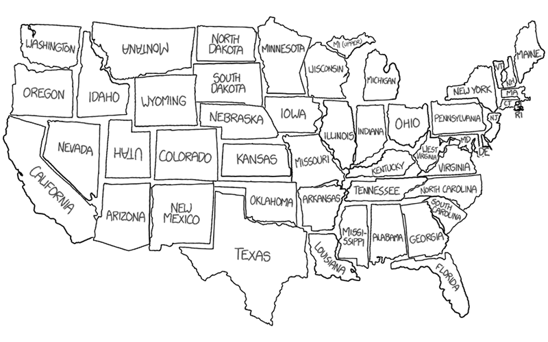
The comic is a map with the (rough) outline of the mainland of the United States of America. At first it looks like the real map, but actually all the states have been shuffled around in it. It seems that Randall took all of the states (minus Alaska and Hawaii the two states that are not part of this map and are only mentioned in the title text, see below), and then reassembled them in the style of a jigsaw puzzle, with the end result being a map with a similar outline to the original unaltered mainland state map. They can thus be reassembled into the real map as can be seen here (see also the trivia section).
This comic may be an input to the way the voting districts in the US are so random that you can not guess where your vote will count. In this video Electoral College Ruins Democracy (by Adam Ruins Everything from November 2015), a map of the US is split up, much like this comic has done. In this case though the states do not move to a new location, but rater move apart to show the size of the state depending on how much your vote would count. The video is about how the Electoral College is assembled in order to elects the President and Vice President of the United States. At the time of this comics release (2016-03-09) the United States presidential primary elections to determine the candidates for the United States presidential election, 2016 was in full progress and not at all determined yet.
Previously Randall has played with the shapes of the united states in 1079: United Shapes. In that map he did two separate drawings for Michigan with a mitten in the lower part and an eagle in the upper part. Once again in this version he has split Michigan in two, the lower main part, the mitten just labeled Michigan, is on the west coast on part of California's location, but the upper part is located on the east coast over New York's location and has been labeled MI (upper). So even without Hawaii and Alaska, there are 49 "states" in this map, consisting of 47 states plus the two halves of Michigan. In the table below all 49 states in the map has been listed to indicate where the puzzle pieces have been moved to.
It seems at a first glance that the names have been written on the states as they would appear in a normal map, and that they have all then been rotated with the rotation of the states. But this is not the case for all states. For instance it seems like Utah has hardly been moved at all, and with the name written normally this may be intentionally to deceive the readers. Because Utah has been turned upside down, and according to how for instance Texas, clearly turned upside down, has it's name written upside down as well, Utah should thus also have been written like that.
It seems likely that this could be a trick by Randall, to see if anyone spots that Utah has actually been moved. But it could of course be a mistake, as seems more likely with Montana where the same "error" has occurred, but since this state has been moved far from it's real position there would be no sport in doing so (see the trivia section). Of course there is the possibility that "Utah" was on purpose and Montana by mistake. With 47 of 49 ending up rotated as expected on the map and only two exactly upside down, there can be no doubt that it was on purpose that the the names are written according to the states rotation for the 47. Note that for instance the state California has been rotated, but in a way so the text is written normally. But due to the direction of the state, it is normal to write the name tilted down along the state, which just coincidentally ends up being rotated normal in the position it has in the comic.
Other states that have not been moved a lot include California which has only been pushed down the length of the west border of the US (and thus rotated acordingly), so the top part still overlaps with the bottom part California, but also Arizona and New Mexico. Maine has only been rolled left (i.e. turned upside down) to just outside its normal position. Colorado has been moved up a state to where Wyoming usually is, and Wyoming has then just been shifted right. But both have been turned 90 degrees, whichever way would be impossible to say for these rectangular states. But the text, if you dare believe in that, seems to indicate they have been turned counter clockwise. Wisconsin has only been shifted down below its usual position but then turned upside down.
The title text mentions how it would be unfair to use a blank version (already created by a user) of this shuffled-up map as a quiz for knowledge of U.S. geography; most people recognize states primarily by their relative locations, not their shape (and especially not their shape after being rotated). It also suggests a corresponding mean trick to play if you include Alaska and Hawaii, which are not present in the comic itself, namely to interchange the volcanic island of Hawaii (consisting of 8 main island and hundreds smaller ones) with those of the Aleutian Islands, also a chain of volcanic islands (14 large and 55 smaller) that partly belongs to the US partly to Russia. The island extends from the Alaska Peninsula. It would thus be possible to even make it difficult to correctly name these last two states, even though it would be obvious to begin with that it must be the two not belonging to the mainland.
Table
- This table list all states in the order of the transcript. But it can be sorted alphabetically.
- It's purpose is two fold:
- To list the rotation of the state compared to the real orientation of the sate in the real world map
- To list which state/states the states, in this comics map, have been moved over/inside.
| State | Orientation | Moved to | Note |
|---|---|---|---|
| Ohio | Upside down | Washington | |
| Georgia | Upside down | Oregon | |
| Michigan (lower part) (as Michigan) | Upside down | Top part of California | Michigan is the only state split in two, as it is also split in two peninsulas in real life. In real life these two parts lies very close on the shores of the Great Lakes, and not as here, with one at each coast of the US. But at least they still both lies on a shore. |
| Maryland (as MD) | Upside down | Middle part of California | |
| California | Rotated counter clockwise | Bottom part of both California, Arizona and New Mexico | |
| Kansas | Upside down | Right part of Washington, top part of Idaho and left part of Montana | |
| Pennsylvania | Rotated clockwise | Right part of Oregon and Idaho | |
| Oklahoma | Rotated clockwise | Idaho and Montana | |
| New Mexico | None | Nevada, and parts of the surrounding states | |
| Nebraska | Upside down | North parts of New Mexico and Arizona | |
| South Dakota | None | Montana | |
| Colorado | Rotated counter clockwise | West part of Wyoming | |
| Wyoming | Rotated counter clockwise | ||
| Utah | Upside down | Utah | Has hardly been moved at all, as the only state, but only rotated. But the text is written upside down on the state, making it appear normal in the comic. This may be an intentional trick from Randall. Only other state where this has occurred is Montana. |
| Alabama | None | ||
| Massachusetts (as MA) | Rotated counter clockwise | ||
| Virginia | Rotated counter clockwise | ||
| Arizona | Rotated counter clockwise | ||
| Washington | Rotated counter clockwise | ||
| Montana | Rotated counter clockwise | Colorado, New Mexico and Texas | The text has been written upside down on the state, so in a correct map using this state the text would be upside down. Only other state this has happened with is Utah. |
| New York | None | ||
| Minnesota | Upside down | ||
| Texas | Upside down | ||
| Connecticut (as CT) | Rotated clockwise | ||
| Mississippi (as Missi-ssippi) | Rotated clockwise | ||
| Nevada | None | ||
| Idaho | Rotated clockwise | ||
| South Carolina | Rotated counter clockwise | ||
| Missouri | Upside down | ||
| Wisconsin | Upside down | ||
| Kentucky | Rotated clockwise | ||
| North Dakota | Rotated clockwise | ||
| Florida | Rotated counter clockwise | Lower part of Michigan and the very top part of Ohio. | |
| North Carolina | Rotated clockwise | ||
| Indiana | None | ||
| Rhode Island (as RI ) | Any clear rotation? | ||
| Oregon | Rotated clockwise | ||
| Iowa | None | ||
| Tennessee | Upside down | ||
| Illinois | None | ||
| Maine | Upside down | ||
| New Hampshire (as NH) | None | ||
| Michigan (upper part) (as MI (upper)) | Rotated 45 degree counter clockwise | Pennsylvania and New York | Michigan is the only state split in two, as it is also split in two peninsulas in real life. In real life these two parts lies very close on the shores of the Great Lakes, and not as here, with one at each coast of the US. But at least they still both lies on a shore. |
| Arkansas | None | ||
| New Jersey (as NJ) | None | ||
| Louisiana | Rotated counter clockwise | ||
| West Virginia | Rotated 45 degree clockwise | ||
| Delaware (as DE) | Rotated counter clockwise | ||
| Vermont (as VT) | Upside down |
Transcript
- [A white map with an outline that closely resembles that of the mainland of the United States of America with gray all around the black border. But on closer inspection most of the states do not look right. The 48 mainland states are all there, however, with their name or abbreviations written on them as a label in gray text. But they have all been shuffled around and then reassembled as a jigsaw puzzle in the same shape as USA. The name labels for most of the states have been rotated, often to follow the new rotation of the state in the map. So some are written upside down or have been rotated 90 degrees clockwise or counter clockwise or even somewhere in between. One state, Michigan, has even been split up in two so there are 49 instead of 48 labels. For the states that have been named only with state abbreviations the full name is written in a brackets behind the transcript of the abbreviation. Here below all the states are listed approximately in columns going from the top left and down and then moving right to the next column across the map. Any rotation of the text from normal is noted in brackets behind the name.]
- Ohio [Upside down]
- Georgia [Upside down]
- Michigan [Upside down – but only bottom part]
- MD [Upside down - Maryland]
- California [Text not rotated, but state is rotated counter-clockwise]
- Kansas [Upside down]
- Pennsylvania [Rotated clockwise]
- Oklahoma [Rotated clockwise]
- New Mexico
- Nebraska [Upside down]
- South Dakota
- Colorado [Rotated counter clockwise]
- Wyoming [Rotated counter clockwise]
- Utah [Text normal, but state is upside down, i.e. the text is upside down in the state]
- Alabama
- MA [Rotated counter clockwise – Massachusetts]
- Virginia [Rotated counter clockwise]
- Arizona [Rotated counter clockwise]
- Washington [Rotated counter clockwise]
- Montana [Rotated clockwise - but the state is rotated counter clockwise, i.e. the text is upside down in the state]
- New York
- Minnesota [Upside down]
- Texas [Upside down]
- CT [Rotated clockwise –Connecticut]
- Missi-
- ssippi [Rotated clockwise - text split with hyphen]
- Nevada
- Idaho [Rotated clockwise]
- South Carolina [Rotated counter clockwise, by more than 90 degrees, but the state is rotated exactly 90 degrees]
- Missouri [Upside down]
- Wisconsin [Upside down]
- Kentucky [Rotated clockwise]
- North Dakota [Rotated clockwise]
- Florida [Rotated counter clockwise, by more than 90 degrees, but the state is rotated exactly 90 degrees]
- North Carolina [Rotated clockwise]
- Indiana
- RI [Label below in the ocean –Rhode Island]
- Oregon [Rotated clockwise]
- Iowa
- Tennessee [Upside down]
- Illinois
- Maine [Upside down]
- NH [New Hampshire]
- MI (upper) [Rotated 45 degree counter clockwise – Michigan but only upper part]
- Arkansas
- NJ [New Jersey]
- Louisiana [Rotated 45 degree counter clockwise - but the state is rotated exactly 90 degrees]
- West Virginia [Rotated 45 degree clockwise]
- DE [Rotated counter clockwise – label to the right in the ocean – Delaware]
- VT [Upside down –Vermont]
Trivia
- Using two A3 printouts of both the real map from Wikipedia and this comic, is approximately the same scale it was possible to reassemble US putting the states in their correct place.
- The result displayed surprisingly accurate drawings of the states, although it is clear that on the borders between states that are not drawn by a ruler, they cannot be correct for both states in all cases.
- From this map it becomes clear that not only Utah but also Montana has the text written upside down according to the correct position of the state.

Discussion
But what prompted this map? Has there been a real life event that influenced Randall to create this? 141.101.91.25 07:32, 9 March 2016 (UTC)
Yes, this is about voting districts. They are so random you can not guess where your vote will count: https://www.youtube.com/watch?v=90RajY2nrgk
08:10, 9 March 2016 (UTC)
- Citation needed. Jkshapiro (talk) 03:22, 10 March 2016 (UTC)
- Definintely a case of [Citation needed]. -Pennpenn 108.162.250.162 03:58, 10 March 2016 (UTC)
(Finally, someone made the page so I can post this. :| )
I removed the names from Randall's map! Here's a blank version! Muahahaha! Quoice (talk) 07:39, 9 March 2016 (UTC)
- Cool. Could you be so mean as to make a version including the shapes of Alaska and Hawaii. You could use the ones from Randall's map of United shapes as templates. That would be fantastic! --Kynde (talk) 09:03, 9 March 2016 (UTC)
Maybe add a table with every state cut out; and add a correct map with the cut out pieces in the right place? sirKitKat (talk) 09:05, 9 March 2016 (UTC)
- That would just be a normal map... The piece could go over a real map in the wrong place to show it. Or rather the entire map should be overlaid on a real map... --Kynde (talk) 09:22, 9 March 2016 (UTC)
- This sounds like a great idea to me! Case of "A picture is worth a thousand words". Elektrizikekswerk (talk) 11:39, 9 March 2016 (UTC)
First thing that comes to mind when I look at the map is seeing New York being against the Mexico border. I wonder how New Yorkers would deal with the Mexicans coming across. --173.245.54.28 14:43, 9 March 2016 (UTC)
This proves it: continental drift is real, and much faster than we thought. 162.158.114.217 15:18, 9 March 2016 (UTC)
 -- Frankie (talk) 15:31, 9 March 2016 (UTC)
- AZ <-> NM 162.158.56.173 16:38, 9 March 2016 (UTC)
- RI should be rotated Azsr (talk) 17:31, 9 March 2016 (UTC)
There's nothing in the article right now that indicates the shapes of the states have been altered slightly so that they fit together seamlessly in this arrangement. I think that's an important point. 162.158.255.80 15:53, 9 March 2016 (UTC)
- I think that's obvious 141.101.70.157 16:18, 9 March 2016 (UTC)
What happened to Long Island (part of NY)? 108.162.218.118 (talk) (please sign your comments with ~~~~)
The article indicates Maine has only been moved, but it's also been rotated 180 degrees. (Upside down) 198.41.235.107 (talk) (please sign your comments with ~~~~)
So glad I'm not in Illinois any more... I guess I'm in Texas now. 108.162.221.18 18:04, 9 March 2016 (UTC)
* Do not use for navigation. Alexbuzzbee (talk) 23:39, 9 March 2016 (UTC)
Reminds me of this MIT Mystery Hunt puzzle from 2013 where you rebuild the US states into a map of Europe: http://web.mit.edu/puzzle/www/2013/coinheist.com/indiana/watch_your_back/answer/answer2/solution.png --162.158.252.185 02:47, 10 March 2016 (UTC)
"Orientation none" sounds strange to me, like saying "no temperature" when it is 0 degrees. Isn't "normal" or "unchanged" better? Jkrstrt (talk) 16:25, 10 March 2016 (UTC)
- ... or change the title of the column to be "Rotation" -- to which "None" is valid 21:54, 10 March 2016 (UTC)
Could someone with more experience than me fix the picture so it's not ginormous? I tried last night and the picture was replaced with the generic "picture failed to load" graphic, same as it looks here: http://www.explainxkcd.com/wiki/index.php/File:1653_United_States_Map_49_piece_jigsaw_solved.jpg NotLock (talk) (please sign your comments with ~~~~)
- I have tried to make a smaller version of it. It can take a while before it uploads so I'm not sure if it has a descend size now? --Kynde (talk) 22:20, 12 March 2016 (UTC)
Would Washington, D.C. move with Virginia, or would it remain physically anchored in its current (real) location? 108.162.218.83 04:47, 11 March 2016 (UTC)
- It could be placed on any state borders, due to it's small size compared to any state, so it makes no sense to ask the question I would say. Anyway it lies insicde Maryland on the border of Virginia so could as well move with Maryland if it was state bound... ;-) --Kynde (talk) 22:20, 12 March 2016 (UTC)
Has anyone sent this to Al Franken? 108.162.245.180 22:04, 11 March 2016 (UTC) I like this map more than the normal one
