1868: Eclipse Flights
| Eclipse Flights |
 Title text: The captain has turned on the 'fasten seat belt' sign. |
Explanation
| |
This explanation may be incomplete or incorrect: No longer bot-made, but could still use work. Do NOT delete this tag too soon. If you can address this issue, please edit the page! Thanks. |
A total solar eclipse will occur on Monday, August 21, 2017. It will be visible as a total eclipse in a narrow band across the contiguous United States starting in Oregon on the Pacific coast and traversing east from there. Cueball asks Megan what she is doing, which turns out to be mapping the flights of aircraft that will be in the air and will fly through the area of the eclipse. She has found between 50 to 100 such flights.
While most flights during the eclipse are coincidental, a few airlines have special flights planned for the occasion. [1]
On the map, the center of the greatest eclipse is shown on the border between Illinois and Kentucky. Cueball says that the airlines and pilots will be prepared and aware of the situation, but Megan wonders what it would be like on a plane with an unprepared crew. The last panel shows a plane flying into the area of the eclipse with one of the crew telling the passengers that the end of the world has come.
The title text refers to the 'fasten seat belts' signs on display for the passengers, as a precautionary measure for turbulence. Many pop-culture depictions of the end of the world feature storms, earthquakes, tsunamis, volcanic eruptions, etc; as the captain believes that the end of the world is upon them, he feels it safe to ensure his passengers are prepared for turbulence from any of the phenomena that occur during the end times.
Transcript
- [Cueball is standing behind Megan, looking over her shoulder as she's seated in front of her laptop.]
- Cueball: What's that?
- Megan: Flight plans. Looks like there will be 50 to 100 flights whose route puts them in the path of the eclipse next month.
- [A map with a shaded path of the eclipse and red planes traveling is shown, with some planes inside the path.]
- Cueball: I'm sure the airlines will be prepared. Pilots know that stuff.
- Megan: But can you imagine being on the one flight where the pilot didn't?
- [A more detailed plane is shown flying into a curtain of darkness.]
- Captain: *KSSCHHH*
- Captain: This is your captain speaking. If you look out the right side of the plane, you'll see, uhh...
- Captain: Folks, this appears to be the end times.
Discussion
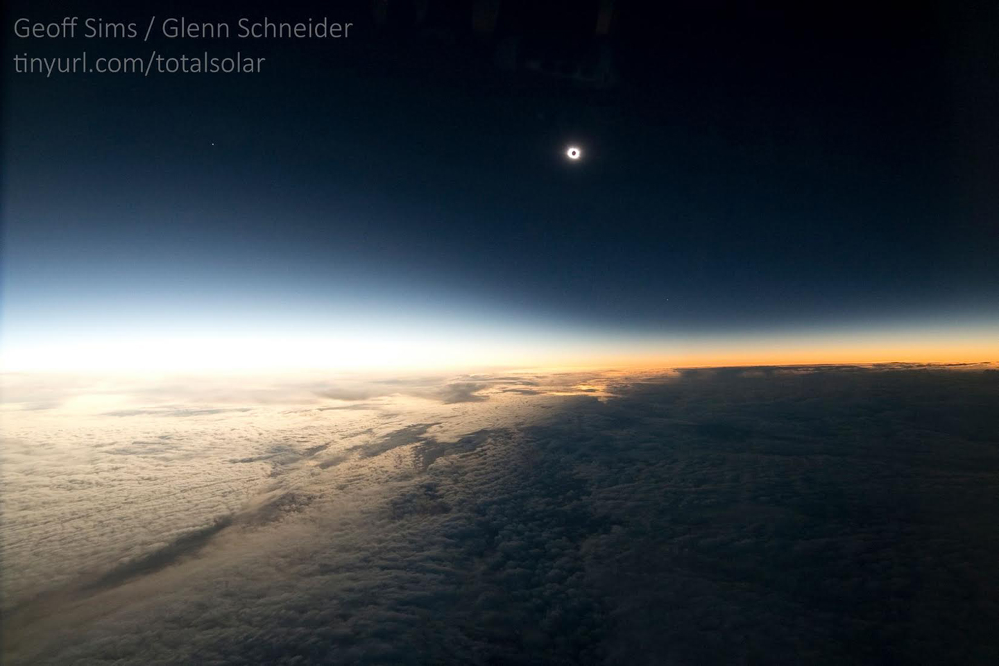
This could use an image. Could someone more versed in this website's inner workings add one please? E.g. http://www.slate.com/content/dam/slate/blogs/bad_astronomy/2015/03/23/sims_schneider_eclipse_mar202015.jpg.CROP.original-original.jpg --141.101.105.12 21:54, 26 July 2017 (UTC)
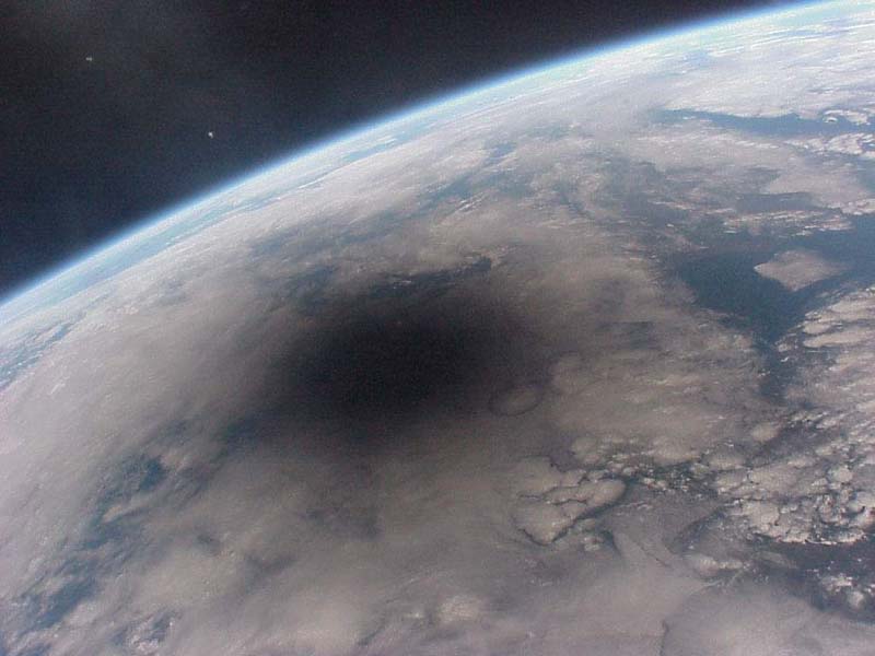
- I strongly suggest this image of a total eclipse shadow taken from the Mir space station. I found it on this introductory astronomy lecture notes page linked from this excerpt:
- While we often sketch the penumbra as uniform, in reality the penumbra shades gradually from the completely dark umbra out towards the edges. The reason is simple: as you move outwards away from the edge of the umbra, you will see an increasing fraction of the Sun peeking out from behind the Moon. There is a very nice Mir image of the 1999 Aug 11 eclipse shadow showing what I mean.
- I also suggest that fact be included into the explanation, because the comic showing a sharp shadow transition is factually completely incorrect. 162.158.166.53 04:45, 27 July 2017 (UTC)
- It's not wrong, it's just a schematic map of the path of totality. There is in fact a sharp distinction between regions that see a total eclipse and the neighbouring regions where it's only a partial eclipse. This graph clearly shows this, instead of the darkness of the shadow created by the eclipse (in which case the central path would've been pitch black). 141.101.88.88 20:33, 27 July 2017 (UTC)
- On the contrary, that "sharp" transition in the Sims/Schneider image spans over a hundred miles because it was taken from an oblique tangental perspective in space. The Mir photo is pointing more directly straight down at the Earth and shows a more accurate representation. 162.158.178.147 05:19, 28 July 2017 (UTC)
- It's not wrong, it's just a schematic map of the path of totality. There is in fact a sharp distinction between regions that see a total eclipse and the neighbouring regions where it's only a partial eclipse. This graph clearly shows this, instead of the darkness of the shadow created by the eclipse (in which case the central path would've been pitch black). 141.101.88.88 20:33, 27 July 2017 (UTC)
I've been looking around, and couldn't find a site to give me flight information for that specific day, and overlaid on a flight path of the eclipse. Anyone have any luck? 162.158.255.118 22:03, 26 July 2017 (UTC)
Does anyone feel as though the explanation is finished? Dontknow (talk) 23:56, 11 September 2017 (UTC)
The airplane depicted is probably a Boeing 737-700. A 737 is recognisable by the "kinked" leading edge to its tail, the presence of blended winglets and a dorsal wifi antenna suggest it is the "Next Generation" series, and the length is most consistent with the -700 variant. D5xtgr (talk) 02:49, 7 June 2020 (UTC)
The xkcd also referenced the April 20 eclipse this year in a recent comic. 172.71.158.231 06:14, 8 May 2023 (UTC)
