Difference between revisions of "Talk:1653: United States Map"
(Voting districts my foot.) |
|||
| Line 7: | Line 7: | ||
(Finally, someone made the page so I can post this. :| ) | (Finally, someone made the page so I can post this. :| ) | ||
| + | :Citation needed. [[User:Jkshapiro|Jkshapiro]] ([[User talk:Jkshapiro|talk]]) 03:22, 10 March 2016 (UTC) | ||
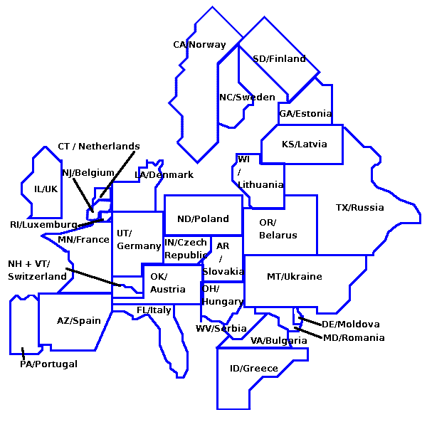
I removed the names from Randall's map! [http://i.imgur.com/Mvi8j9s.jpg Here's a blank version!] Muahahaha! [[User:Quoice|Quoice]] ([[User talk:Quoice|talk]]) 07:39, 9 March 2016 (UTC) | I removed the names from Randall's map! [http://i.imgur.com/Mvi8j9s.jpg Here's a blank version!] Muahahaha! [[User:Quoice|Quoice]] ([[User talk:Quoice|talk]]) 07:39, 9 March 2016 (UTC) | ||
Revision as of 03:22, 10 March 2016
But what prompted this map? Has there been a real life event that influenced Randall to create this? 141.101.91.25 07:32, 9 March 2016 (UTC)
Yes, this is about voting districts. They are so random you can not guess where your vote will count: https://www.youtube.com/watch?v=90RajY2nrgk
08:10, 9 March 2016 (UTC)
(Finally, someone made the page so I can post this. :| )
I removed the names from Randall's map! Here's a blank version! Muahahaha! Quoice (talk) 07:39, 9 March 2016 (UTC)
- Cool. Could you be so mean as to make a version including the shapes of Alaska and Hawaii. You could use the ones from Randall's map of United shapes as templates. That would be fantastic! --Kynde (talk) 09:03, 9 March 2016 (UTC)
Maybe add a table with every state cut out; and add a correct map with the cut out pieces in the right place? sirKitKat (talk) 09:05, 9 March 2016 (UTC)
- That would just be a normal map... The piece could go over a real map in the wrong place to show it. Or rather the entire map should be overlaid on a real map... --Kynde (talk) 09:22, 9 March 2016 (UTC)
- This sounds like a great idea to me! Case of "A picture is worth a thousand words". Elektrizikekswerk (talk) 11:39, 9 March 2016 (UTC)
First thing that comes to mind when I look at the map is seeing New York being against the Mexico border. I wonder how New Yorkers would deal with the Mexicans coming across. --173.245.54.28 14:43, 9 March 2016 (UTC)
This proves it: continental drift is real, and much faster than we thought. 162.158.114.217 15:18, 9 March 2016 (UTC)
 -- Frankie (talk) 15:31, 9 March 2016 (UTC)
- AZ <-> NM 162.158.56.173 16:38, 9 March 2016 (UTC)
- RI should be rotated Azsr (talk) 17:31, 9 March 2016 (UTC)
There's nothing in the article right now that indicates the shapes of the states have been altered slightly so that they fit together seamlessly in this arrangement. I think that's an important point. 162.158.255.80 15:53, 9 March 2016 (UTC)
- I think that's obvious 141.101.70.157 16:18, 9 March 2016 (UTC)
What happened to Long Island (part of NY)? 108.162.218.118 (talk) (please sign your comments with ~~~~)
The article indicates Maine has only been moved, but it's also been rotated 180 degrees. (Upside down) 198.41.235.107 (talk) (please sign your comments with ~~~~)
So glad I'm not in Illinois any more... I guess I'm in Texas now. 108.162.221.18 18:04, 9 March 2016 (UTC)
* Do not use for navigation. Alexbuzzbee (talk) 23:39, 9 March 2016 (UTC)
Reminds me of this MIT Mystery Hunt puzzle from 2013 where you rebuild the US states into a map of Europe: http://web.mit.edu/puzzle/www/2013/coinheist.com/indiana/watch_your_back/answer/answer2/solution.png --162.158.252.185 02:47, 10 March 2016 (UTC)
