Talk:2577: Sea Chase
The flag on the lefthand ship (port-side, if you will :P) looks like the Rising Sun Flag that the Japanese Navy uses as its ensign. 172.70.110.147 02:31, 5 February 2022 (UTC)
- Actually, that the Navy used in 1889 (not uses). 172.70.110.147 02:31, 5 February 2022 (UTC)
- I reckon it looks more like a Jolly Roger. 108.162.249.87 02:44, 5 February 2022 (UTC)
- Ah, you're right. I was thinking Union Jack for a minute but thought there were too many streaks. The upper and lower portions of the skull nearly touch the edge of the flag, making it look like something akin to a sunburst. 172.70.114.99 02:46, 5 February 2022 (UTC)
- If you look at the 2x size image and zoom in it is very clearly the Skull and Crossbones flag from pirates. Which makes a lot of sense. --Kynde (talk) 17:27, 13 February 2022 (UTC)
- Ah, you're right. I was thinking Union Jack for a minute but thought there were too many streaks. The upper and lower portions of the skull nearly touch the edge of the flag, making it look like something akin to a sunburst. 172.70.114.99 02:46, 5 February 2022 (UTC)
- I reckon it looks more like a Jolly Roger. 108.162.249.87 02:44, 5 February 2022 (UTC)
Okay, I added an initial description for the title text and made a bunch of edits. I'll stop now to let other people get in on the action. :P 172.70.114.99 02:54, 5 February 2022 (UTC)
- Yeah, I kept edit-conflicting (except the first time, when I ended up just appended to some else's first edit) and I think I have reached the point where I've unruined everything of everyone else's that I didn't fully intend to change or add to. But it's late (GMT) and I need my sleep so if I've accidentally rushed through some stuff I shouldn't have then please fill your boots and tweak it back (or onwards) to how it should be. G'night! 162.158.159.11 03:07, 5 February 2022 (UTC)
- G'night. I think we were conflicting. It was my first experience live editing and it was fun. lol 172.70.230.157 03:08, 5 February 2022 (UTC)
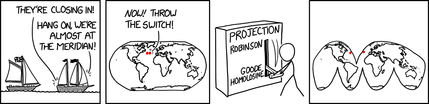
If that is the goode one, I'd like to keep clear of the Baad Homolosine. 141.101.105.41 14:08, 6 February 2022 (UTC)
What's the reason for thinking the ships are sailing towards Europe? The prevailing wind in the north Atlantic is more or less westerly, so ships tacking into the wind are more likely to be heading west. 162.158.222.155 20:00, 6 February 2022 (UTC)
- They're pointing right, which matches the map? (Was posting the following comment, but might as well answer this straight away.) Also, being chased by a pirate towards all those lovely New World riches seems funny idea, on balance. Although of course it depends on when and how a privateer discovers a possible prize... for some reason in the very middle of the Atlantic rather than in a more bottlenecked part of the trade-routes. Perhaps the merchantman was spotted leaving the vicinity of Bermuda (they have the sails for it!), with signs of carrying cargo of value, and it was considered worth chasing all the way to the mid-Atlantic, just about catching them up. The voice 'from the map' comes from the Easterly ship, as well, so that can really only mean that it went just a little more east prior to the gap-in-the-map appears and it would make Europe the most practical destination afterwards. As for the winds, matching the map position with prevailing/trade-wind diagrams, they could easily be caught in a north-westerly/north-easterly zone that naturally forms a gyre in the atmospheric flow (on average, and of course passing weather systems can send contrary winds any which way off the various edges of a rotating or counter-rotating pressure-system as it moves loosely across the ocean. On the whole I think it was a reasonable assumption to make that they're Europe-bound (by inclination and/or because that's the way the chase takes them), based upon both illustrative convention and the general logistics of the situation, but then with the possible top-mast flags 'error' I'm not sure exactly how strictly Randall intended this all to be. He could have colour-coded the dots, individually, if he was even that bothered - not just made them both red. 172.70.85.79 20:23, 6 February 2022 (UTC)
- Very long explanation for nothing ;-) That they are sailing east is clear from the fact that the red dot closest to Europe is the one being chased, and it just crosses the meridian from the west to the east so they can throw the switch. End of all other arguments. ;-) --Kynde (talk) 17:27, 13 February 2022 (UTC)
- Westerlies blow from the West to the East. It could be argued they're within the Trade Wind latitudes, but the ships are positioned far enough up North for me to believe they're meant to be in the Westerlies. 172.70.230.157 21:35, 28 February 2022 (UTC)
So by my (less than encyclopedic) reckoning, that's a fast gaff-rigged sloop flying chasing what appears to be a more cumbersome gunter-rigged (or bermuda?) schooner (iffy on that one, but it's not a ketch). What's most strange is that they're triangular, not square, as a merchantman/non-raider should need (especially in a chase such as this) as much sail as possible just to get its deeper and wider hull moving. Neither are using topsails, maybe because the wind conditions are contrary. Yes, the top-flags are pointing backwards, but then that's also a common artist error (with anything other than a modern wingsail), while both ships are flying clearly foreward sails (not spinnakers, I'm sure) and the chased one seems distinctly inflated to the direction of travel. Era-specific peculiarities are beyond my easy assessment (or indeed what century such an encounter might actually be in). 172.70.85.79 20:23, 6 February 2022 (UTC)
- I think it is safe to say that Randall did not think too much about how the ships sails worked. For one if the ship has the wind in from the back, then the flags would blow the other way, since the ship will never sail as fast as the wind. --Kynde (talk) 17:30, 13 February 2022 (UTC)
- Nah. Randall knows full well how sails and flags work. I reckon he deliberately drew it that way to drive traffic to this site. We should thank him. :-) --172.70.90.121 16:06, 1 March 2022 (UTC)
It should be noted that the Dymaxion map used afloat would almost assuredly be of the "contiguous oceans" variety of projections, not one of the versions that splits the oceans to produce contiguous land masses... 162.158.107.104 16:21, 7 February 2022 (UTC)
Changing the projection would be extremely unhelpful for any other ships traveling the Atlantic between North America and Europe which hadn't arrived at the meridian yet, as they would have to travel hundreds of miles out of their way to continue their journey. Not to mention, any ship that was on the meridian elsewhere in the ocean would be split in half. --172.70.178.25 21:42, 7 February 2022 (UTC)
- The strange large anachronistic square incongruous inscribed otherworldly ¿synthetic? reality-warping switch....
Interesting edits about the switch, along the way. Generally I think compounded adjectival descriptors go by the order of opinion, size, age, shape, (existential) quality, colour, origin, material and purpose - though there are disagreements and alternate versions of that list. What is incongruousity? An opinion or a quality (or origin, at a push?), I'd guess, making each order potentially valid. (In advance of any further arguments, I suggest "strange large" rather than an edit-war, though I personally like its incongruousness being mentioned, and incongruousicity in general. YMMV.) 162.158.159.73 17:22, 5 February 2022 (UTC)