2854: Date Line
| Date Line |
 Title text: They estimate the rocket should be free by approximately ... uh ... well, in about two hours. |
Explanation
| |
This explanation may be incomplete or incorrect: Created by a SNAGGED LINE - Please change this comment when editing this page. Do NOT delete this tag too soon. If you can address this issue, please edit the page! Thanks. |
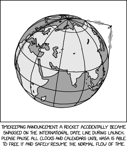
The International Date Line is a line on Earth near the antimeridian (180°) that marks one of two places on earth where the date changes (the other being the time zone line that currently separates 11 pm from midnight local time). The International Date Line is not a physical string, and therefore could not be caught on by a rocket. It should also be noted that the International Date Line is not a straight line, but extends far from the antimeridian to avoid cutting countries like Russia in half, cutting them off from their trading partners, like Kiribati, or cutting off outlying territories, like the Cook Islands from New Zealand.
Based off where the map shows, the Rocket was most likely launched by the Russians, possibly from the Baiknour Cosmodrome. Of course, the odds of a rocket getting stuck on such a line (if it existed) would be incredibly slim. Additionally, striking such an object wouldn’t trap the rocket. Instead, the rocket would discover what many KSP users have, a Rapid Unplanned Disassembly.
The title text refers to how this event has temporarily paused time, and to how that means ‘they’ can’t give a time for when it will be fixed. If, say, it was 8:00 when the rocket got snagged, then it is 8:00 until they fix it. This means that no matter how much time passes, until they fix it, it will be 8:00.
Transcript
| |
This transcript is incomplete. Please help editing it! Thanks. |
- [The earth, with the date line as a physical band being pulled off of the surface by a rocket, cutting into the land on the other side.]
- Caption: Timekeeping announcement: a rocket accidentally became snagged on the international date line during launch. Please pause all clocks and calendars until NASA is able to free it and safely resume the normal flow of time.
Trivia
- This trivia section was created by a BOT
- The standard size image was uploaded with a resolution/size larger than the supposed 2x version.
- This may have been an error.
Discussion
The 'standard' and '2x' sized images had unexpected sizes, so a Trivia section has been automatically generated, and an imagesize parameter has been added (at half size) to render the image consistently with other comics on this website. --TheusafBOT (talk) 22:56, 13 November 2023 (UTC)
- I see no evidence of this, so the Trivia section should probably be removed. The comic appears standard sized on XKCD (both in the page and if opening the direct link), and the link in the Trivia also leads to a standard size image. NiceGuy1 (talk) 04:19, 19 November 2023 (UTC)
- Things have been known to be corrected. For whatever reason, TheusafBOT detected the initial issue (since it was made to do so, these problems recently having occured in other comics and caused problems) and it certainly was worth the automatic note making to make people aware of the (probable) discrepancy.
- Without looking into possible webarchived material, or delving too deep into the current stock, I think it's worth keeping a small note (just as when the original "neeeded" was corrected to "needed" in a title text, etc), but obviously reword it as being no longer true (and/or change link to the erroneous size's archive location, if there is one?). I would also then see no problem with fully excising the 'BOT announcement here (and your response and this response to that) here on the Talk page.
- If you'd prefer to excise the "Trivia", then I suggest transfer the gist (not header) here to Talk as a quote/indent, so future readers know what we're talking about, and leave this part of the fuss intact. (Same for any other such 'corrected' anomolies you can find needing sorting out in other comics, albeit their Talk elements are probably thankfully unaugmented by this particular metaⁿ-discussion.)
- I'm sure if you edit it all how you want to, though, it'll all be critically assessed by every other editor who cares (myself, I care little about this particular issue, just 'best wiki-keeping practices' in general, not liking to lose information that has been 'true') and modified/whatevered at their whim, just as we gladly honour/humour your own edits.... ;) 172.70.85.208 14:32, 19 November 2023 (UTC)
- Meant to add: the "evidence" for it is in the following comments, editors who witnessed this. Which is good enough for me to be a fact (and not even a {{fact}}). 172.71.178.68 14:38, 19 November 2023 (UTC) (aka 172.70.85.208, above, in case that has changed)
Is it just me or are these size errors becoming more common? What going wrong in the infra? 172.69.62.90 22:57, 13 November 2023 (UTC)
- Yeah, and this one came in HUGE. The image size upon loading the comic at xkcd.com was 6642x7838. At first, I thought it was a special comic or an interactive one. But just huge. Orion205 (talk) 00:25, 14 November 2023 (UTC)
added an explanation 172.70.174.61 23:49, 13 November 2023 (UTC)
The IDL might not normally be straight, but when the rocket pulls in it, it will straighten it out. Barmar (talk) 00:54, 14 November 2023 (UTC)
The Kentucky State Police resent the implication about their organizational infrastructure.
I like how this comic came out the same day (in UTC+10) as I am studying Earth geometry including the IDL. Nice little coincidence. OmniDoom (talk) 03:46, 14 November 2023 (UTC)
Why's there a missing line of latitude? 172.68.140.145 05:47, 14 November 2023 (UTC)
- That is actually a good question. Seems like an error. --Kynde (talk) 08:01, 14 November 2023 (UTC)
- I would assume the lines that are shown are intended to be the equator, tropics, and arctic circle (antarctic being hidden out of view), being the most commonly known lines of latitude.172.70.85.151 12:04, 14 November 2023 (UTC)
- The latitude lines, the top one is obviously the Arctic Circle. The next goes through the northern part of Africa, making it the Equator. Next would be a Tropic. Where's the northern Tropic? (I always mix up Cancer and Capricorn, I want to go with Cancer). Missing line. NiceGuy1 (talk) 04:19, 19 November 2023 (UTC)
- I think it's just the angle. If viewed from the side (instead of diagonally above as in the image), I think they would appear more equidistant. Or maybe they're based on a different projection entirely, that wouldn't be out of character for Randall either. 172.70.46.254 12:08, 14 November 2023 (UTC)
- No, the northern Tropic is missing. After Arctic it shows the Equator, there should be a Tropic in between. NiceGuy1 (talk) 04:19, 19 November 2023 (UTC)
- I'm not seeing the problem, I guess? The northern Tropic passes through northern Africa; that's not the equator. The equator passes through the *middle* of Africa (south of India, through Indonesia and the Philippines, etc.), so from the north pole the drawing does show the Arctic Circle, then the Tropic of Cancer, then the equator, then the Tropic of Capricorn way down at the bottom. https://en.wikipedia.org/wiki/Tropics#/media/File:World_map_indicating_tropics_and_subtropics.png -- ModelD (talk) 13:27, 21 November 2023 (please sign your comments with ~~~~)
Even if the lines were actual physical strings/ropes, they appear to be lying right on the earths surface instead of being suspended in mid air. So how would a rocket accidentally get snagged on one? You'd have to purposefully shove the rocket between the earth and the line before launch. Bischoff (talk) 08:39, 14 November 2023 (UTC)
- Well, obviously you wouldn't want ships/trains/etc hitting them as they moved longitudes(/latitutudes) or timezones, so they must be held up out of the way by skyhooks. Probably also above plane travel, or we'd see them being snagged quite often...
- Noting that I had to caveat the idea of the Russian launch-site, as NASA seems to be the named agency needing to fix the mess. Could of course be 'Hollywood Exceptionalism', regarding who it is who
leadssaves the world. Or actual expertise such as might have actually helped with the Kursk submarine, in a pinch (except that, geoplitically, currently it'd probably take even longer for Russia to deign to request assistance from the US than 23 years ago). - I also, for brevity, skipped the needless pedantic analysis of typical 'first orbit' trajectories from all current launch sites, worldwide, so as to work out whether any others might encounter such a North Pacific crossing-point at 'first hit' (after which, it's clearly high enough to not snag again). Depending on launch eccentricity, it's feasible from practically any of them, naturally. 172.69.195.51 10:37, 14 November 2023 (UTC)
- Maybe it was a submarine launched rocket.172.70.86.53 12:06, 14 November 2023 (UTC)
- It's obviously North Korean. Russia disclaims any involvement. 172.71.102.143 08:42, 15 November 2023 (UTC)
I think the "about 2 in the title text references the Windows approximate download times dialogs - GreyFox 172.71.150.133 18:31, 14 November 2023 (UTC)
- It's not. They were about to say an absolute time, e.g. "by approximately 12:00" but they realized absolute time is paused so they gave a relative time instead. --NeatNit (talk) 22:39, 14 November 2023 (UTC)
This looks devastating for western Europe and western Africa. --NeatNit (talk) 22:39, 14 November 2023 (UTC)
I just tripped over the 90º24’ line. What is with these new strings? TenGolf MathHacker (talk) 15:12, 15 November 2023 (UTC)
