2888: US Survey Foot
| US Survey Foot |
 Title text: Subway refuses to answer my questions about whether it's an International Footlong or a US Survey Footlong. A milligram of sandwich is at stake! |
Explanation[edit]
This comic pokes fun at the difference in length between the US Survey Foot and the International Foot. After Carl Edvard Johansson's gauge blocks in 1912 led to an international agreement in 1959, the foot has been defined to be exactly 0.3048 meters, whilst the US survey foot continued to use the definition of 1893, making it a bit longer than the international foot at 1200/3937 meters. However, the difference between the two is proportionately too small to be meaningful for most purposes, as they differ by only 2 parts per million. At foot-length scales, the difference is a fraction of a micron, with longer measures (where the error grows to a notable degree) requiring an already excessive implied precision likely to mismatch its true accuracy. Some engineering or scientific applications may involve such tolerances, but would be expected to consistently use some more modern standard of measurement, such as SI (the Metric System), to avoid such confusion.
In the third panel, Cueball says that someone is using the survey foot again. It turns out to be Black Hat, acting in a way that sounds very typical for him. Cueball claims that he is drawing the world 610 nm closer to madness, which is about the difference per foot between the two measures. Cueball, outraged, then says that the National Institute of Standards and Technology (NIST) will capture Black Hat to stop him from using the US survey foot. One joke here is that his coordinates show that he is 8000 miles away, but since he is using the US survey foot, he is 0.016 miles (around 25.75 meters or 84.48 feet) away from the search team, making them unable to find him at that exact spot. They are probably at the same lake in the last two frames, with maybe only some bushes separating them; a good strike team would likely keep looking in the area, but perhaps being strictly NIST-trained to adhere to particularly exacting standards has ironically made them vulnerable to the same inaccuracies that they are supposed to be preventing.
Part of the joke is the imaginative idea that NIST employs and dispatches strike teams to apprehend persons that use incorrect measurements. This may be a play on words about the Nuclear Emergency Support Team, or "NEST", a United States Department of Energy group who respond to nuclear and radiological emergencies such as reactor accidents or nuclear terrorism, and who might reasonably have access to resources such as the helicopters depicted during a crisis.
The title text references a 2013 lawsuit over the length of a "Footlong" sandwich sold by the Subway fast food chain. However – in contrast to the issue at stake in that lawsuit – the difference in length between an 'international footlong' sandwich and a 'US survey footlong' sandwich is far below the precision or accuracy by which sandwiches are usually produced, making it understandable that Subway would not think it necessary to clarify which definition of 'foot' they use for their products.
Absurd outcomes from updated survey standards was also the topic of 2920: Survey Marker.
Explanation of the comic's underlying assumptions and implications[edit]
Randall appears to be playing a bit fast-and-loose here. To make this joke work implies a rather imaginative situation: that both Black Hat and the searchers have set their devices to measure and report location in reference to the same location (the place where Cueball is, at one end of the 8,000 mile measurement) and not just use a satellite navigation system like GPS and lat/long like every other smartphone on the planet.
In the unlikely event that the searchers' phones measure and report location in reference to Cueball's location, evidently Black Hat has also overridden his device's in-built GPS to report its location in reference to Cueball's location as a way to toy with him and the NIST teams, and then traveled EXACTLY 8,000 survey-foot miles away, knowing NIST would be able to track him and that a team would be sent in pursuit. After all, Black Hat is known for his preternatural powers of mischief.
The punchline of the comic still doesn't make much sense though. The difference between the two definitions of the foot (8,000 miles vs 8,000.016 miles) is a little under 85 feet, and the background of the last two comic panels suggests that Black Hat and the NIST team are both standing next to the same pond on the other side of a bush or rock. Given that humans can easily see for miles, it is extremely unlikely that the NIST team would not be able to see Black Hat walking away. Even if they could not on the ground because of the rock/bush in the way, they should have easily done so from the helicopter as they approached. Furthermore, Black Hat is shown as humming or singing due to the musical notes by his head, and once again humans can easily hear someone humming or singing from about 85 feet away in a quiet forest.
Though Cueball’s location is not specified, one potential location is NIST headquarters in Gaithersburg, Maryland, or another governmental location, perhaps in the Greater Washington Area where most US government agencies and departments are headquartered. These options are supported by the panel in which Cueball mentions a NIST team is on their way and brags that “we” are going to capture him. This language implies that Cueball either works for NIST or for a larger effort in which NIST is a partner. These location options are also supported by the fact that Cueball’s location is used for the origin point of the 8,000-mile measurement, suggesting that he’s speaking at a flagship location and not a random office building.
The use of helicopters — which cannot fly 8,000 miles unaided — also suggests an imaginative situation in which NIST teams with access to helicopters are distributed around the globe, perhaps at US air bases and on US aircraft carriers.
Real world examples[edit]
In the early 2000s, Survey Foot/International Foot conversion issues created difficulties in the civil engineering industry after a commonly used CADD design software package changed how it processed units. Prior versions of the software program Microstation were unit-agnostic, relying only on absolute coordinates assigned to elements from survey data. Starting with Microstation Version 8, internal software calculations were performed entirely in metric units and relied on a units definition file to seamlessly convert to the unit system being used for a project. The default options in the program being “Foot” (i.e., International Foot) or “Survey Foot”, many users were unaware of the difference and selected “Foot” even when a project’s field survey was performed in survey feet. In the US, most states have their own coordinate systems, referred to as State Plane Coordinates, to correct for the approximation of projecting the Earth’s spherical surface into a cartesian X,Y plane. Some states have coordinate zones which span their entire length, so a project’s coordinates can be millions of feet from the origin, a scale on which the minuscule difference between Survey and International feet conversion becomes whole feet.
In another famous example, a building in Arizona was required to be built one story shorter than planned. The building was going to be 20 stories tall and almost in line with an international airport runway. It was designed to be one foot north of the FAA mandated flight path for runway approaches, which it would otherwise violate due to its height. However, the building was surveyed in international feet (the legal standard in Arizona) while the flight path was defined in survey feet (used nationally by the FAA). The baseline that defined coordinates in this part of Arizona was about a million feet away, which added up to a difference of about two feet. As a result the building would have been inside the FAA flight path, and to avoid this the building had to be reduced to 19 stories so it was below the exclusion zone.
Transcript[edit]
- [Closeup on Cueball.]
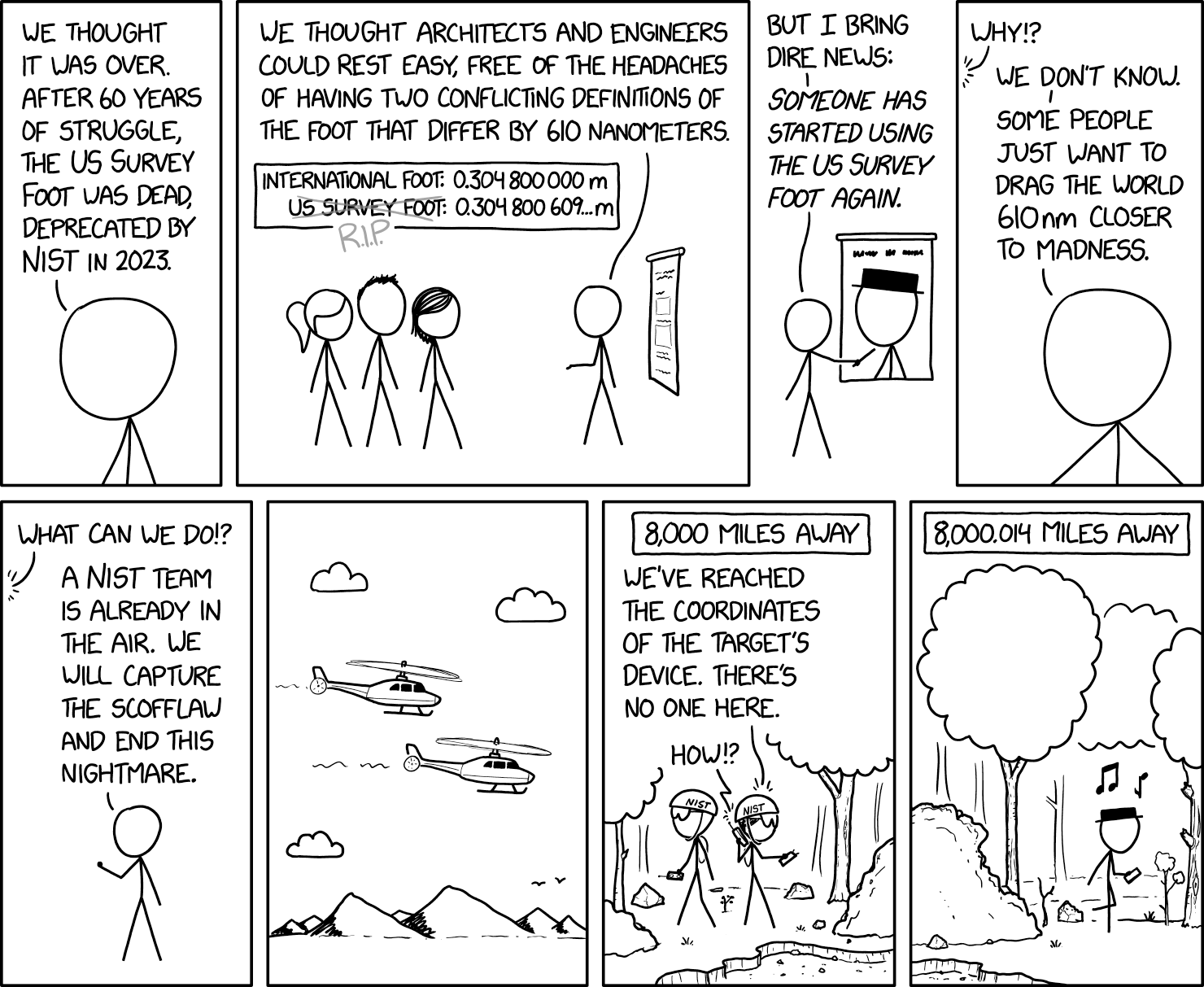
- Cueball: We thought it was over. After 60 years of struggle, the US survey foot was dead, deprecated by NIST in 2023.
- [Cueball is shown to be talking to Ponytail, Hairy, and Megan. He has a presentation behind him.]
- Cueball: We thought architects and engineers could rest easy, free of the headaches of having two conflicting definitions of the foot that differ by 610 nanometers.
- International foot: 0.304 800 000 m
- US survey foot [crossed over in gray] R.I.P.: 0.304 800 609... m
- [Cueball points at an image of Black Hat with unreadable writing above it.]
- Cueball: But I bring dire news:
- Cueball: Someone has started using the US survey foot again.
- [Closeup on Cueball again.]
- Off-panel voice: Why!?
- Cueball: We don't know.
- Cueball: Some people just want to drag the world 610nm closer to madness.
- [Farther view of Cueball only. He clenches a fist.]
- Off-panel voice: What can we do!?
- Cueball: A NIST team is already in the air. We will capture the scofflaw and end this nightmare.
- [Two helicopters flying, with mountains in the background.]
- Caption: 8,000 miles away
- [Two operatives in a forest by a pond with NIST helmets. One talks on a walkie-talkie.]
- Operative: We've reached the coordinates of the target's device. There's no one here.
- Voice from walkie-talkie: How!?
- Caption: 8,000.016 miles away
- [Black Hat walking elsewhere in the forest, apparently by the same pond. He is holding something resembling a phone.]
- Black Hat: ♫ ♪
Trivia[edit]
In the original version of the comic, the number of miles in the last panel was 8,000.014, but was changed to 8,000.016. The latter matches the 2 ppm difference between the international foot and the US survey foot.
![]() Add comment
Add comment ![]() Create topic (use sparingly)
Create topic (use sparingly) ![]() Refresh
Refresh
Discussion
Breaking news- the comic just got changed to 8,000.016TenGolf MathHacker (talk) 17:28, 31 January 2024 (UTC)
- As it should ... I did the math, and the difference between the two measurements over 8000 miles comes out to be 25.7249999 meters – which works out to be 0.0159842 of a mile. This is, of course, why it appears that the team and Black Hat are on the shores of the same pond, with only the boulder(?) preventing the team from being able to see Black Hat. RAGBRAIvet (talk) 10:25, 1 February 2024 (UTC)
So no one has caught on to the fact that the imagery of last panel appears to be a continuation of the second-to-last panel? 172.71.155.18 (talk) 19:02, 1 February 2024 (please sign your comments with ~~~~)
- Too obvious to mention explicitly. Although it does place his location at far less than 8000 miles'-worth of accumulated error. Consider it a figurative continuation. 172.69.43.170 21:23, 1 February 2024 (UTC)
- He isn't 8,000 away from the NIST team. The NIST team is 8,000 miles from Cueball, Black Hat is 8,000.016 away from Cueball. The distance between Black Hat and NIST is 0.016 miles. :) i.e. same lake. NiceGuy1 (talk) 06:45, 3 February 2024 (UTC)
- "8000 miles'-worth of accumulated error" isn't the full 8000(.016) miles, if that was what you were trying to clarify. Its the ±0.016 miles.
- Also, current explanation says "25.749 metres, being unusually close compared to what the comic seems to depict", yet (depending upon how contiguous or uncontiguous the pond(s), rock(s) and presumably the same woodland is (it's drawn as not only inter-panel-border difference in distance, but may be not be very much more, perhaps less than a full further tween-panel would depict) I get the impression that he is actually closer than the 25m discrepancy. (As in the NIST team leader just needs to say "spread out!" and someone on the team almost instantly wanders into him by default.) 162.158.74.49 11:47, 3 February 2024 (UTC)
- (cntd) There was an edit more in agreement with me (that they were close). But suggested definitely frame-border close, which I (I hope they don't mind) hedged to it not much more than (probably) frame-border close. To cover the actually unknown exact relation between the obviously related neighbouring scenes. 162.158.74.69 22:17, 3 February 2024 (UTC)
- He isn't 8,000 away from the NIST team. The NIST team is 8,000 miles from Cueball, Black Hat is 8,000.016 away from Cueball. The distance between Black Hat and NIST is 0.016 miles. :) i.e. same lake. NiceGuy1 (talk) 06:45, 3 February 2024 (UTC)
- UK & Ireland Survey Foot
Until the British Ordnance Survey adopted the metre they used a foot of 0.304 800 749 1 metres. RogerWTurner (talk) 19:34, 9 February 2024 (UTC)
- So US Miles, UK Miles, and "International" "Imperial" Miles are all different?172.69.194.202 12:10, 1 February 2024 (UTC)
- US and UK/Commonwealth "statute miles" are 1609.344 metres (exactly, since 1959). Though based upon shared origin of 5280 (English) feet. That's probably as International as you can get. (5280*610nm is 3.2208mm of difference if you get mixed up.) But it took a while to even get to "roughly that exact".
- The Roman Mile was 5000 (Roman) feet, approx 1480m, but led also to the Italian Mile of 1852m-ish by various convolutions, whilst the Chinese 'Mile' is officially 500m. Even within Britain, the Scots Mile was 1807m-ish (as seen between some historic roadside mileposts) and the Welsh version was once around 6,170m (even more historic/obsolete).
- Even nautical miles are 'wrong' against what they should be, but are nonetheless standardised to their own separate international standard. (You could say "they're in a league of their own", but then leagues can be anything from 2.2km to 6.6km, at least, depending on where/when you are!) You can probably look all this up, if you really want. ;) 172.71.242.204 12:54, 1 February 2024 (UTC)
There are (or used to be) states that specify U.S. survey measure for various things. Others that specify the international definition. Still others that just leave it undefined. Seems normal.
Although it IS a small difference, the survey grid in the U.S. and thus the property lines for a large portion of the U.S. are done with the older definition and a few reference longi- and latitudes. That could make property lines suddenly shift, so the U.S. survey foot may never fully die. I even made sure it's in my app accurately.
162.158.159.236 19:39, 31 January 2024 (UTC)
Someone should mention who NIST is (National Institute of Standards and Technology). I'm only familiar with them because of their work with information systems.
- And maybe something about the absurdity of NIST having "SEAL Team"-like agents that can capture someone violating their standard. Barmar (talk) 07:20, 1 February 2024 (UTC)
- The explanation doesn't mention the NIST helicopters (which have no precedent), but somehow doubts the US would send a SEAL team where they have no jurisdiction (which does). 198.41.242.118 14:00, 1 February 2024 (UTC)
- The Department of Education and the Internal Revenue Service both have SWAT teams, so NIST having them doesn't actually seem that outlandish to me. - Someone born near Waco. 104.23.195.23 21:11, 19 May 2025 (UTC)
No Ingenuity tribute comic? :/ 162.158.102.64 21:07, 31 January 2024 (UTC)
- Perhaps he couldn't make his original attempt fly? 172.69.43.170 21:24, 31 January 2024 (UTC)
I love XKCD, but it isn't often they make me laugh out loud. The sheer absurdity of this, and that Randall picked up on it did. 172.68.144.147 21:05, 31 January 2024 (UTC)
I measured the 2 feet that I have readily available. None of them come close to either the International or US Survey foot. And most worrying, the difference between them is significantly more than 610nm.... 172.71.99.49 11:19, 1 February 2024 (UTC)
- You sure you measured correctly? The proper direction is lengthwise... 172.68.138.166 15:47, 1 February 2024 (UTC)
- Please consult a healthcare professional immediately. Laser813 (talk) 20:23, 1 February 2024 (UTC)
- You are non-standard. You will be eliminated. SDSpivey (talk) 17:45, 2 February 2024 (UTC)
I would think 0.016 miles would be close enough for the NIST team to be like "There he is!", :) I love how it looks like they're both on the same lake, what's with "being unusually close compared to what the comic seems to depict", to me it's DEPICTING them pretty close! NiceGuy1 (talk) 06:45, 3 February 2024 (UTC)
I know that this is a semantically annoying nit to pick, but the overall theme of the comic is about the difference between the two original measurements, not how much .016 can make in measurements. So why is decimal variance the punchline? 1245 UTC, 6 Feb 2024. 172.70.34.122 12:47, 6 February 2024 (UTC)
- It's the punchline from the absurdity that two entirely separate units existed for which even over a great distance of 42.2 million feet, the variance would be only 84 feet. I had projects come to a screeching halt when the survey/international issue made stuff be wrong by less than 2'. It ends up that property owners get very protective of their property lines being exact. 172.70.126.49 (talk) 21:02, 16 February 2024 (please sign your comments with ~~~~)
- Prior to 1959 the UK foot was defined by a physical object (unlike the US one which was allready defined based on the meter), so all conversation to meter where purely empirical. Hence the change was simply a measurement refinement / redefinition, akin to the multiple redefinitions of the meter and kilogram. The UK didn't have the difference at the survoyer scale issue, as UK survoyers had allready adapted metric back then.
- There's a lovely scene in one of Heinlein's less popular books. A man from the 1950's is being interrogated by a man from the distant future, and is asked how precise a survey marker from the time would be. The character indicates it should be precise to less than half an inch. The future-man is furious that he's being lied to and asserts the 50's man must be ignorant and therefore just guessing. 50's man assures him he would know because he was a surveyor himself. -- A fan of precision measurements. (PS in the version of ACAD I use, you can set the units to nanometers or parsecs (as well as other boring units in between.) 172.69.74.231 21:53, 19 May 2025 (UTC)
- India did have a survey foot, but this has been retired since then.--172.70.246.85 17:30, 27 March 2024 (UTC)
- Interesting! What was it called? Z1mp0st0rz (talk) 15:48, 16 April 2024 (UTC)
 Add comment
- Interesting! What was it called? Z1mp0st0rz (talk) 15:48, 16 April 2024 (UTC)
- India did have a survey foot, but this has been retired since then.--172.70.246.85 17:30, 27 March 2024 (UTC)